
A 14 day traverse of the Western and Eastern Arthurs, Tasmania! 50 year old me and 3 Gen Y hiking buddies. Age doesn’t matter (so they say). What does qualify you for this hike is an expertise in ducking, weaving, hurdling, limbo dancing, carrying a VERY heavy pack, a vague love of heights, a penchant for putting on soggy socks each morning, cairn spotting, and finally a love of “type 2 fun” (look it up on Urban Dictionary) http://www.urbandictionary.com/define.php?term=type+2+fun.
This walk has a well-deserved reputation for being one of the hardest in Australia, and the walker registration books indicate that a significant number of people quit. Prepare well. If it looks like becoming type 3 fun for you, then turn back!
Preparation
Being the Gen X in the group, I was not aiming to leave anything to the last minute. Hence, pretty much all my gear and food was ready a week before departure.

14 days food and gear (almost)
By the time I had added a stove, 2L water & a few of those last minute “I just might need that” things, the pack and contents came in at about 23kg – the most I have ever carried. The picture pretty much says it all. I love my home dehydrator and vacuum sealer, but to cut down on weight I added freeze dried meals as well. Freeze dried was just fantastic on those extra-nasty weather days. PLB was an essential (in Australia these now have to be registered with the Australian Maritime Safety Authority). We had a basic Garmin etrex 10 GPS, colour-photocopied & laminated sections of the relevant TasMaps (Federation, Glovers, Crossing, Razorback 1:25000 Series), photocopies of relevant pages from John Chapman’s book “South West Tasmania”, 5th ed. This book is a must-read before this trip. We frequently referred to him as “JC” whenever discussing advice from the book. My son also carried a 7mm, 20m rope for the group. I should also mention that the whole trip was instigated and organised by him.
Getting there
3 of us caught the 7am flight from Melbourne to Hobart, picked up by the 4th member of the team. A shopping trip to downtown Hobart reaped fuel canisters, waterproof matches, a lighter, and last minute food (including my son’s 1kg block of cheese!). Just in case you are interested, we carried a Jetboil MiniMo stove, which has a 1L pot, plus we took a larger Jetboil pot. The 4 of us had spare fuel leftover at the end, having purchased one 450g and two 230g canisters.
We were blessed to be driven to the start of the Huon Track, the trip taking approximately 2 hours from northern Hobart.
Day 1
Huon Track (Picton River) > Harrisons Opening
15km+, 7.5 hours
Initially the track feels very sane, with a lovely start sign, civilised sign-in shelter, and a boot wash down station. A plant disease called “Phytophthora Root Rot” tends to target the buttongrass moorland.
A few km’s on, and civilisation ceases. Blakes shelter is no longer. We spotted some corrugated iron on the ground which we assumed was the former site. The term “shelter” looks as though this was a very generous label when you look at old pictures of the structure. The “Yo Yo” nature of this stretch becomes a reality, and lasts near to Cracroft. Most of the day we could smell and see smoke from the bushfires in NW Tasmania, but as we made camp at Harrisons Opening rain fell (as it did every day thereafter!) and the smoke was not to be seen again.
Camp 1 Harrisons
Day 2
Harrisons Opening > Cracroft Crossing
The walking has been SO slow, averaging 2km/hr. 10km today felt like 20km. The Yo Yo track is relentless, and particularly so with 14 days of food on your back. The crossing point for Cracroft River was further on than at first thought. There are several small campsites initially which lead you to believe that you are at the river crossing point. Make sure you do approximately 200m due south, past the acute bend in the river, before you cross at an open beach area.
Mid afternoon the 2 blokes took off on the track towards Pass Creek with just less than 1/2 our food. They set a time goal and ended up hanging the food in a tree at Strike Creek so they’d have time to return before dark. The GR for the food plant was E570 N193.


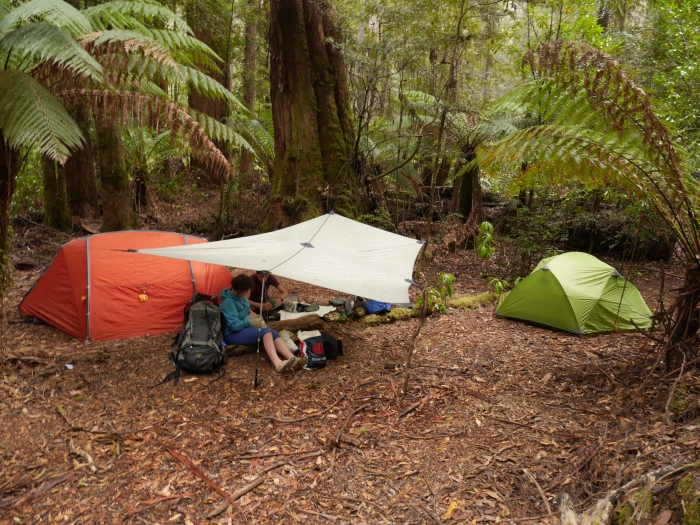
We decided to experiment with 1 Sea To Summit dry bag, and 1 Glad ForceFlex garbage bag! 8m of p-cord was plenty. The bags were suspended 3m off the ground.
Girls got to set up camp, do some laundry and have a brief relax (an absolute luxury for this trip). The camp is a significant distance from water so water carriers are a bonus.
All in all, I would have to say that the 1st 2 days have been somewhat of a soul crushing experience for me considering the pack weight. So glad to get rid of some food – for now.
The first sighting of the “Arthurs” is possible from the boardwalk just beyond the campsite.
Day 3
Cracroft Crossing > Junction Creek

Even though the packs were lighter and most walking was on the plains, this was a huge day in terms of distance, about 20km. Initially your feet are greeted by narrow boardwalk. The plains then give way to a series of creeks and marsh and the boardwalks disappear totally. Over the last 10km we got hit by strong crosswind and rain/hail. During our trip planning we had thought we may not make it all the way to Junction Creek today but the atrocious weather spurred us on, with the thought that we may not make any ground tomorrow.
Each of us had significant shivering upon arrival at the Junction and fumbled around with tent and tarp gadgets for ages. A freeze dried dinner tonight – not much energy for cooking. Late in the afternoon 3 guys passed through camp having made an attempt on Alpha Moraine to start the Western Arthurs, but were forced to U-turn due to the weather. They didn’t appear the next day, so I think they had given up and walked out to Scotts Peak.


Evie’s mung beans refused to sprout. Too cold and not enough of the sunny stuff.
Day 4
Tent bound.
Rain, hail, wind……ditto, ditto, ditto. I wondered if it may be snowing up on the Arthurs.
Awesome outdoor drop toilet at this camp, but not at all private!
Long breakfast, long map read. Played cards in the tent – Scumbags & Warlords and 500. The Gen Y’s blitzed me. Group conferencing re: the trip ahead – we agreed our original trip route was still achievable if the remaining weather is OK and we push on to Oberon tomorrow.
Dinner was the quinoa, potato, apricot, pea and shitaki mushroom special.
Day 5
Junction Creek > Lake Oberon
0740 – 1715 with 1.5 hour lunch
Alpha Moraine much easier than I had anticipated, perhaps because it is the most frequented access route for the Western Arthurs and has priority maintenance. Yesterday’s day in the tent was disappointing in that the weather had not seemed to receive our itinerary, but as we neared the top of the moraine and headed onto the true start of the traverse I was thankful that we hadn’t been up here yesterday.
This was the easiest section of the ranges traverse, with rock steps and a clear track.
We found the infamous “cave” at Square Lake, where some intrepid young hikers (including my husband) had taken shelter with his group during bad weather 30 years prior. This cave shelter is on the left, just as you approach Square Lake. It was a U-turn for them!
![]()
The drop down to Lake Oberon was spectacular, but also the first point that got my heart racing and knees shaking. There are several tent platforms at Oberon and we had the privilege of choice – as was to be every night from now on. Our camp set up routine was now well and truly established, with a snug tent huddle, tarp between, and cup of tea before cooking dinner. Fresh food stir fry – a treat.
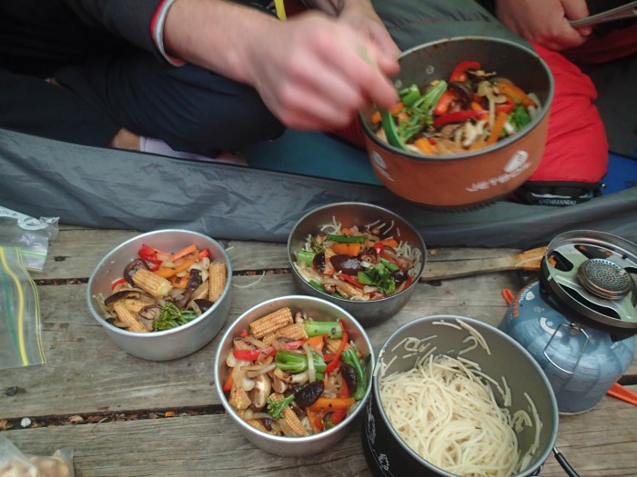
Gourmet stir fry
Day 6
Oberon > High Moor
1030 – 1800. 7 hours walk to cover 4.3km!!
I have to confess that I didn’t sleep at all last night. I must have been anxious about the day ahead and whether I could cope with the heights (as per JC’s book)
At times the route is dangerous, being poised above high cliffs, and it requires many climbs up and down steep gullies
JC
Alas, no pack hauling needed! Just pack passing (we coined the term “PRP” to indicate that the person below was in a safe Pack Receiving Position!) Near the top of Mt Pegasus we chain lifted our packs through a narrow hole underneath huge boulders.

No option but to take packs off here
Hand holds, foot holds. The rock has lots of grip, even when wet. Low cloud. Intermittent rain. The route does now very much penetrate the roughest part of the range, with serrated ridges.


Even after Luke’s delicious vegetarian spaghetti bolognese for dinner I could not sleep well. Awake with uncontrollable shaking in my legs for about 2 hours. Perhaps the start of the roughest part of the route has eaten away at my muscle tissue?

High Moor Camp 6
Day 7
High Moor > Haven Lake
1000 – 1730. Not quite JC time.
A cold pack up this morning, the first time I’ve pulled out my gloves. Steep ascents/steep descents – this is what the “Beggary Bumps” are in essence. The Tilted Chasm I enjoyed, perhaps because my confidence was starting to lift, and Evie has been awesome in helping me find footholds and being my very thoughtful “PRP” person.
We met Lucy (from Adelaide) with her dad and friend (from Bordertown) and dropped down the Chasm together. These were to be the last people we saw for the rest of the trip.

Rain plus Chasm = descending with a creek running underneath you. Our feet have started to show the effect of constant moisture!

maceration madness
We enjoyed a small, snug tent platform which seemed quite sheltered, despite the fact that JC labels this as “dubious shelter”.
Actually, I was enjoying the snug set-up until the extra rank odour in the tent got to me. My son announced that he’d left his deodorant in the food drop, hanging in the tree, back at Strike Creek. “Strike a Light” is what us Aussies would say!
Come to think of it our enjoyment was cut short prematurely, just after dark, when Bryce’s kidney beans made a reappearance, thankfully caught in one of the many ziplock bags you take hiking! Warning: do not take a pack of dried kidney beans – they just don’t rehydrate (unless you are at home and can cook them for several hours). The human gut, as Bryce found out, is not good at being a substitute rehydrator for these deceptively delicious looking legumes!

Haven Lake Camp 7
Day 8
Haven Lake > Promontory Lake
1130 – 17.30, 6 hours. Again, beyond JC hours.
The day Evie’s pack rolled down a ravine and into Lake Sirona. Fortunately the pack did not wipe out Bryce on the way down. Lesson learnt = even if you drop a pack a wee distance onto a seemingly flat area during a descent, it still has significant bounce and is highly likely to defy gravity and not stay on that flat area. Shoes and toilet trowel parted from her pack on the way down, but apart from that very minimal damage or water leakage.
With the cloud being so low many days, and the macro view of the world obscured, I enjoyed focussing on some of the micro creation near my feet.


Having got this far I found that the final 6 days beckoned. We were more than half way through the trip, and 1 day on from my previous longest hike of 7 days. Stinky, but then we all are. Will the food drop be there tomorrow? Will we even make it that far tomorrow?
Home dehydrated apricot chicken made up for the fact that this campsite was my least favourite.
Day 9
Promontory Lake > Off Track, near Strike Creek
0810 – 2120. 13 hour day.
First sunrise for the trip, yey!. Up, up, up to The Phoenix, past West Portal, then onto the Crags of Andromeda. Crag, after crag, after crag. The eventual sighting of the long, flat top of Lucifer Ridge was a relief.

Lake Rosanne
It was 6pm by the time we arrived at Lake Rosanne, so we ate dinner there, then ploughed on. It was late, so we decided not to take the Lucifer Ridge option to get to the Pass Creek track to collect our food. The track leading towards Cracroft Crossing became quite indistinct once back down on the Arthur Plains. It surprised me. I had thought this would be a frequented route for people coming off the Western Arthurs and returning to the Junction Creek/Scotts Peak carpark. Perhaps most people exit the Western Arthur range earlier on Kappa Moraine.
To cut a long story short, we got lost. Kind of. Luke had a GPS trajectory set for our food drop, and initially it seemed achievable. Afterall, it was “only 2.2km” to our goal. The sun was well on the way to setting, we had pulled our head torches out, and were still thrashing about in the mud, cutting grass and creeks at 9pm! Time to bail out onto the nearest buttongrass plain and set up tents.

Off Track camp 9
Day 10
Off Track camp > Stuart Saddle
1045 – 1730
Woke up on an open buttongrass plain. Made our way to Luckman’s Lead (amazing what a difference daylight makes).
Evie and I waited for Luke and Bryce to pick up the food drop. They already looked tired coming back along the track 1.5hrs later, each carrying a bundle. Thanks guys. It saved us quite a few km’s with big packs on. Everything was found intact up the tree! No clear winner between the garbage bag and dry bag – both did a stellar job!
Our packs are heavy again but we are all in a better mood with more calories on board.
Then it was up, up, up again. This time the track did not seem as frequented as Alpha Moraine. How on earth did Mr Luckman chart the original route? Huge machetes, and buckets of courage? Evie and Luke took some of my pack contents to pull me through.
Stuart Saddle camp was my fave. No toilet but it has a new water tank and 3 tent platforms.


Day 11
Stuart Saddle > Hanging Lake
7.30 -4pm at HL junction.
 The route first thing this morning was one of many that initially looked “improbable” but as we sidled our way close under the cliffs of The Needles the route gradually unveiled itself as “probable”. Fed Peak still seemed so far away!
Lunch at Goon Moor campsite. Lovely site. Water tank but no toilet. Goon Moor was named after Roy Goon, the first pilot to do a food drop on the Moor, in 1948 (somehow I don’t think goon sacks were around then).
Luke, Evie and Bryce parted ways with me at Hanging Lake junction, left their packs, and headed for Fed Peak. There’s just no way I had the energy to attempt Fed at the end of another long day. Google Earth doesn’t do the Arthurs justice in terms of relecting the ruggedness and steepness. I’ve included an aerial pic from dougthost.com which really does portray the reality beautifully. Lake Geeves is in the foreground and you can just spot Hanging Lake if you follow the steep slope up from the left side of Lake Geeves. https://deeteephoto.wordpress.com/2012/01/30/federation-peak-and-the-western-arthur-range/ 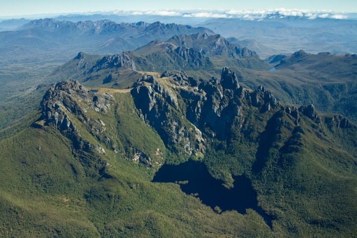
I descended the 15min track down to Hanging Lake, set up a tent, then headed for the Lake for a wash and laundry session. The loo has a great view to Lake Geeves.


Balmy evening, very unusual, and the only one all trip. Quite different to what was looming for the next day.
Soaked Bryce’s chick peas, hoping they would be more tummy-friendly than the kidney beans.
The others appeared way up at the top of the track, in the gap between the rocks, at 8.30pm, head torches on, ready to tell their own story about the Fed Peak ascent.


Day 12
Hanging Lake > Bechervaise Plateau (upper terrace)
Weather change overnight. Cold, wet – what’s new?
2.5 hour delay on the way getting lost down a wrong gully after Chockstone Gully. We mistook a “rock block” as meaning a cairn. This is marked as “wrong way” on the map at the beginning of my blog! Believe you me, I made a very clear “rock block” for all future wanderers.
We had originally been aiming to do Moss Ridge in the afternoon, but by the time we arrived at Becherviase (2.30pm) and read the track notes we decided it was too risky to attempt, particularly factoring in that we may lose daylight before any camp spot. It was also the wettest day so far. Glad we made the call to not attempt the infamous Ridge.
Feeling a bit anxious about doing Moss Ridge tomorrow – had psyched myself up for it today.
Day 13
Becherviase Plateau > Forest Camp
7 hours

Beautiful, but a day of this gets to your brain!
The Ridge was relentless – mud, tree roots, steep drops (including a plank walk which Evie said made her feel like a koala!) but none of it exposed. We have not used the rope, thanks to my team of pack passers.
I’m so glad that we did not descend or ascend this ridge with packs full of food.
Pulled into camp with a lump on my right patella – hope it’s not fractured. Leeches loved my hands, mainly due to all the cutting grass lacerations enticing easy access to blood.
Happy campers tonight, the end is in sight.
Home-dried Moroccan lamb with cous cous for dinner
Day 14
Forest Camp > Farmhouse Creek carpark
08.50 – 18.30
Phew! Tree roots, mud, cutting grass, occasional coloured tapes showing the way. My pack feels like a day pack (finally). Lots of talk about food and stopping for fish and chips on the way home.
The last campsite talked about in JC’s book no longer exists, so this gave us extra incentive to walk on to the carpark.
Pot luck dinner with all the left-overs (not much). All consumed in faith that tomorrow Verity will arrive and more calories are on the way…..flap jacks particularly.

Farmhouse Creek carpark Camp 14
Carpark camp, riddled with leeches. But who cares, this is the last tent pitch. The wind roars through the valleys, like a locomotive passing through town.
Day 15
Yey, Verity arrived at about 11am, hauling an esky full of delicious bounty out of her boot: brie cheese, fresh seed bread, grapes, plums, egg mash. Plus, of course, the promised flapjacks!
Huonville stop for hot chips.
I feel the fittest, but tiredest, I have ever been in my 50 years. Have had micro-tears in every major leg muscle and stretched my hips, knees and shoulders to their end range and beyond many, many times. I am not sure where this quote is from but it seems very fitting here:
Somewhere towards the end of multi-day walks, I usually find fatigue and fitness intersecting. They are uneasy acquaintances, eyeing each other with ill-disguised suspicion. Each perches on a shoulder, leans into an ear, makes its case.
Lessons Learned
A 4 season tent is ideal. The wind roars through the Arthurs.
Bring calorie-rich food and don’t feel at all guilty about it. You’ll need the energy. I lost 2.5kg over the 14 days.
Fuel: 230g canister will do 4 people for 4 days, providing you pre-soak food or are using freeze dried. We took x1 450g and x2 230g canisters.
Take a pack big enough to put everything inside – having stuff hanging off your pack just doesn’t work well in the Arthurs. We constantly spotted pieces of someone’s blue foam sleeping mat over several days. What did they have left to sleep on?
Dry bag everything which matters inside your pack – don’t rely solely on a rain cover or pack liner
Take a cup made from thick plastic or stainless steel, in case your pack rolls down a ravine and into a lake (in which case your thin plastic cup make get smashed)
Wool layers under rain gear – oh so toasty
Have 1 set wet gear and 1 set dry. Live in the same wet socks for the whole hike – drying socks? Dream on! Don’t try to dry them in your sleeping bag overnight either.

Take a sponge (Wettex) to wipe down tent before pack-up and inside floor after set-up + useful to prevent tarp friction rub wear on outside top of tent – place it between fly and tarp
Not all camp sites are near water. Take a cask wine bladder/goon sack or 2 for water carting
Take a tarp and one set of walking poles. Make a tent huddle if you can. Great for cooking (which will, invariably, be in the rain, plus it’s comradery boosting)
Nalgene bottle with some duct tape stored around it – very accessible
Spare p cord/shoe laces – someone is bound to discover their boots falling apart.
Tree roots are your friend and enemy: a day climbing over them drives you crazy, but then they provide awesome hand holds
I was hopeless at cards, but I definitely won the “struggle face” award
Keep an eagle eye out for cairns, and check that a pile of rocks is not actually a “rock block” trying to prevent you from that path of travel.
Leeches don’t like toothpaste
If at all possible, get picked up by a vet at the end of your hike – they are pro at removing ticks completely and quickly
Make thin custard and have it as a hot drink dessert
Check that your tent buddy son does not put his deodorant in the food plant parcel
Don’t take “dry kidney beans”. These take ages to try and dehydrate, even after a day of soaking in a jar.
Home dehydrated and vacuum packed food is ideal in terms of weight, taste, and packability. Freeze-dried is lighter of course, but gets expensive for a long expedition.
John Chapman is a super-human bushwalker. We very quickly learned to take on his more generous time estimate, but only one day came in = to this once. Add on another hour or 2, particularly if you have a 50 year old in your group
Take a pack of cards for tent-bound days, but try to find a pack of waterproof ones – everything gets soggy
A huge variety of dried vege’s can be found in Asian supermarkets
Take good quality zip lock bags to pack food in. Ziploc brand 1 gallon bags (I bought mine at Costco) lasted the 14 days
Carry a 20m 7mm rope. You may not end up using it but it will give peace of mind.
What looks “improbable” from a distance will slowly appear “probable” as you get closer.
It’s no good having a Telstra SIM card if your phone is crap!
Cairns and rock blocks are life saving
JC’s “sidle” = hang on for dear life, using whatever you can get purchase on, whilst hugging the side of a steep, rocky crag

Great write up! It’s a rough walk to be sure, but a rewarding one. Congratulations to your whole group on the effort!
LikeLike
Thanks for taking a look at my blog Jessica. Might see you on a trail one day!
Loved your Mt Anne Circuit report. Pretty special doing a trip with both your parents.
LikeLike
Great blog. Really useful info. We did a week into the Arthurs in April. Had perfect weather. Planning to do the full traverse. Your blog will help in the planning. Probably my favourite hike in Tassy.
LikeLike
Thx for reading my Arthurs blog Mark. Let me know if you need further details about any stage of the “traverse”!
LikeLiked by 1 person
I will do that. Thank you. We plan to do In January.
LikeLike
Hi is there any chance I could get the gpx file for your full traverse walk ? we want to do the exact same route and would really appreciate having the file if possible. Great blog also, thanks for writing it up cheers
LikeLike
Garry, great to hear you’re planning the traverse. My son has the GPX file. It’s on his blog soon. lukefrisken.com
LikeLike
Hi guys, was great to meet you on the Western Arthurs. After leaving you we went down K moraine and pounded away for a 30km day to Wullyawa Creek until we could not take another step. We had a plane to catch and had a lost a day getting from L Oberon to High Moor. I came across your blog as I am researching for Eastern Arthurs trip in 3 weeks time! I am going back for more punishment! Planning Farmhouse Creek to Fedder, Lucifer Ridge, K Moraine and back out YoYo track. Regards Jeff (Bordertown)
LikeLike
Glad you found my blog Jeff. All tbe best for your next Arthurs adventure. I’ve just returned from Pine Valley/Labyrinth/Acropolis area. Think i need to live in Tassie!
LikeLike
Jeff
Some time had passed, but did you managed to conquers the Eastern Arthurs?
LikeLike
Love this write up Jane – In the planning stages with friends to do Arthurs in Jan (If the borders allow) I love the comments on John Chapman’s notes – my group have previously done a few other hikes in Tas with his notes in particular South Coast and had many a word to say about “Chapman” and not the least Monica and their timeframes. Hahaha makes for great trail chat when when you’re seriously hungry and done with the day.
LikeLike
All the best with your planning Melanie. Thanks for reading.
John and Monica Chapman are certainly Australian bushwalking icons. They’re super-fit, wonderful people who have contributed much behind the scenes as well as sharing so much wisdom through their guide books. Hope you meet them on the trail one day!
LikeLike
Great read. Brings back memories of traverses in the 80s, pre crowds, platforms and toilets (all of which I’m happy about but not for me now). In my seventies now confined to Overland Track, Port Davey Track and such. In Winter too; don’t like flies or crowds. Reading about sidling reminded me that back in the eighties we used Chapmans guide but I remember he published some amendments. Things such as “sidle down to the left” that should have been “down to the right” left some of us geographically embarrassed. Moss Ridge was horrible even then but the logging road didn’t reach Farmhouse Creek. Stopped about a kilometre short. Great photos too.
LikeLike
Thanks for taking a read Ian. This trip is becoming a distant memory now!
John and Monica are still going strong in the bushwalking community – they have a fantastic way of writing up trips.
Walk on,
Jane
LikeLike